Town of Cottesloe Coastal Hazard Risk Management and Adaptation Plan (CHRMAP)
Coastal Hazard Risk Management and Adaptation Plan (CHRMAP)
Consistent with State Planning Policy 2.6, the strategic purpose of the CHRMAP is to determine the risk and required mitigation against inundation and erosion of the Cottesloe coastline from climate change. The findings will inform the Town’s various planning and asset strategies.
At the December 2024 Ordinary Meeting, Council accepted a draft CHRMAP for the purpose of community consultation.
Feedback for this community consultation has now closed.
CHRMAP - R07 updated - Summary Report - V03 - August 2025
CHRMAP - R07 - Draft Summary Report - V02 - February 2025
CHRMAP - R06 - Chapter Report - Implementation - V03 - Final - August 2025
CHRMAP - R05 - Assessment of Risk Treatment Options Cost Benefit Analysis - V02 - Final - February 2024
CHRMAP - R04 - Chapter Report - Risk Evaluation and Risk Treatment Options - V02 - Final - November 2023
CHRMAP - R03 - Chapter Report - Vulnerability Analysis - V02 - Final - September 2023
CHRMAP - R02 - Stantec - Chapter Report - Risk Identification Report - Final - May 2023
CHRMAP - R01 - Chapter Report - Establish the Context - V02 - January 2023
Background:
The Town of Cottesloe received partial funding from the Department of Planning, Lands and Heritage to assist in preparing its first ever Coastal Hazard Risk Management and Adaptation Plan (CHRMAP). This will identify key assets along the coast and determine what measures the Town can take to preserve them against the impact of coastal hazards.
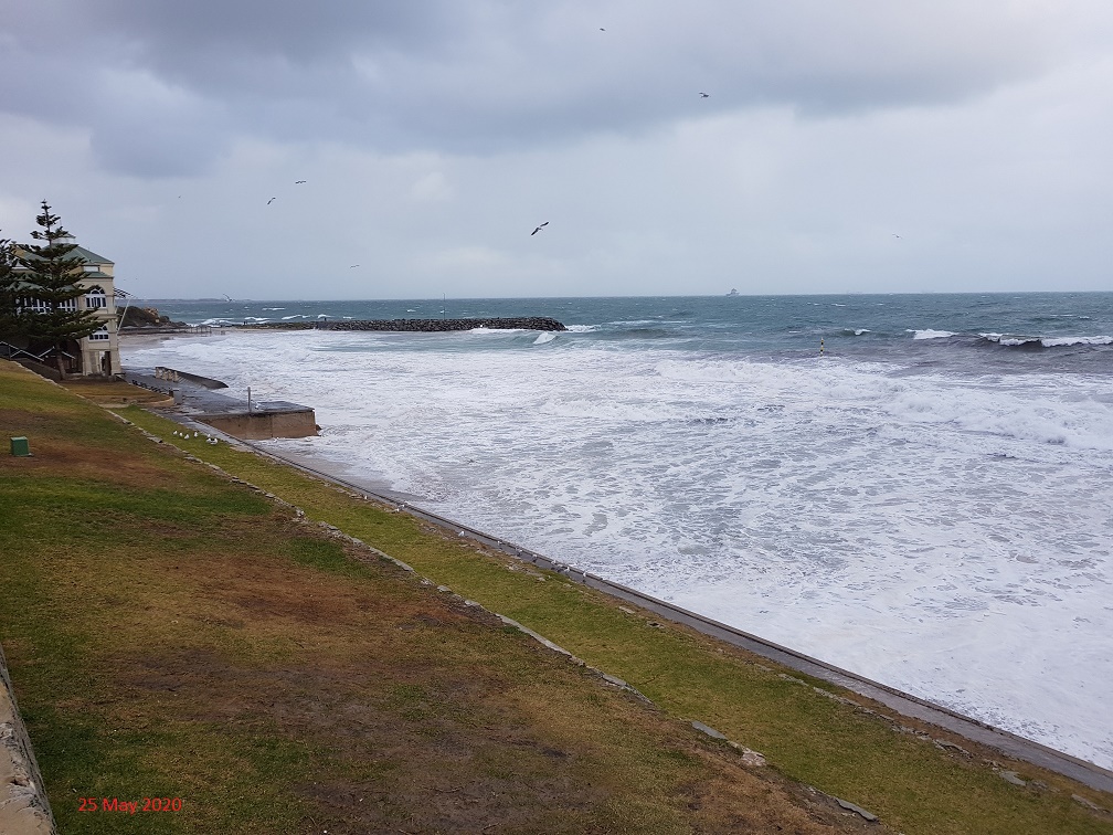
The study area is located on Whadjuk Noongar land and bordered by the suburb of Cottesloe. The approximate 4 km of coastline contains some of Perth’s most iconic and popular beaches and lies between North Street and just South of the Vlamingh Memorial.
The study area includes many well-known landmarks and recreational features including Cottesloe main beach recreation area, Cottesloe Surf Lifesaving Club, The Cottesloe Sundial, Indiana, South Cottesloe playground, Cottesloe Nature Discovery Space, the Vlamingh Memorial, several public beaches and hospitality venues, as well as the Cottesloe and Beach Street groynes. The study area also covers the Cottesloe foreshore masterplan concept and redevelopment area.
Policy and Guidelines
The CHRMAP will be prepared in accordance with the WA Coastal Zone Strategy, the State Planning Policy 2.6 – State Coastal Planning Policy (SPP2.6) and the CHRMAP Guidelines.
Details on the strategic and policy intent can be found at the following links:
WA Coastal Zone Strategy
State Coastal Planning Policy 2.6
Coastal Hazard Risk Management Guidelines - July 2019
We need to start preparing for climate change and coastal hazards
It is now widely acknowledged that we are living with the effects of climate change and Cottesloe’s beaches and beloved infrastructure are at risk of being significantly impacted by this in the future.
Climate change, including rising sea levels, is predicted to increase the level of erosion of beach areas and inundation (flooding) of nearby low-lying areas, including the Cottesloe foreshore. The coastal assets in this area, including recreational spaces, businesses, residences and natural assets, will face increased pressure in the future from the effects of rising water and coastal erosion. This area already suffers from sand erosion and damage due to winter storms and large tides on a regular basis.
Accepting this as an ongoing concern has highlighted the need for the Town to start thinking about how to mitigate these hazards, together with the community, to ensure that this area can be enjoyed for many years into the future.
The Cottesloe CHARMAP is the first step in doing this.
FAQ’s
What is a Coastal Hazard Risk Management and Adaptation Plan (CHRMAP)?
A CHRMAP is a long-term plan to address the impact of coastal hazards on our coastline. It looks at various scenarios within 25-, 50- and 100-year time frames and, with input from the community and key stakeholders, identifies the most appropriate adaptation strategies and options.
What is a ‘coastal hazard?
When we say ‘coastal hazards’ we mean, naturally occurring events that impact our coastline, such as coastal erosion or flooding (also referred to as inundation).
Erosion is a process where parts of the shoreline are worn away due to waves, tides, wind or human activities. It can change the shape and form of the coast, reducing the area between the ocean and features on the land, and even allowing inundation
Inundation is when water occupies previously dry land. It can be temporary or permanent:
Permanent inundation refers to the loss of land due to sea level rise.
Temporary inundation is the flooding of an area due to storm surge, high tides or large waves.
What might be the strategies and options for managing coastal hazards?
There are four overarching ‘strategies’ to manage coastal hazards. These are:
|
Avoid (erosion and inundation)
identify ‘non-build’ area for the future
|
Managed Retreat (for erosion)
withdraw, relocate or abandon assets at risk
|
|
Accommodate (for inundation)
continue to use the land but accommodate changes by building on piles or converting land use
|
Protect (erosion and inundation)
use hard or soft solutions to protect land from the
sea / river
|
Within the strategy/ies chosen, the CHRMAP can further specify options to manage coastal hazards. These include, but are not limited to:
-
Building Design
-
Planning Controls
-
Engineered Structures (eg Seawalls, Groynes, Breakwaters, Revetments)
-
Nature Based Solutions (eg Beach nourishment, Planting)
As someone who lives, works and/or recreates in Cottesloe, how could the outcomes of the CHRMAP affect me?
The inherent nature of a CHRMAP is to look ahead several decades into the future and propose potential solutions to perceived changes along the Cottesloe coastal foreshore. In the short term there may be minimal or no impact to your use of the area. It is most likely that the next generation will experience the impact of coastal hazards and change in usage.
While this is a strategic, long-term plan for managing coastal hazards, it is important for the community and key stakeholders to be involved. We want the plan to reflect what is important along the coastline, what you want future generations to be able to enjoy and what management options to introduce to ensure this.
How can the community be involved?
There are several opportunities for the community to provide input during the CHRMAP process.
-
Register your interest via the Cottesloe CHRMAP webpage to stay informed and be invited to engagement activities
-
Attend one of our Community workshops to discuss the effects of sea level rise and how to mitigate these.
So far the community has been involved through stakeholder interviews, attending information sessions and a coastal values survey.
Who is funding the preparation of the CHRMAP?
Funding for the preparation of the CHRMAP is jointly funded by the Town and State Government.
However, the long-term financial implications and funding options to implement planned coastal adaption strategies will need to be considered.
I don’t feel that climate change is real or could impact me, therefore I don’t understand why the Town is investing in a CHRMAP.
Regardless of whether you believe climate change or not, coastal erosion and inundation is already impacting the Cottesloe foreshore and shoreline assets.
The CHRMAP will look at current coastal hazard risk and provide management options for now and into the future, if the risk increases due to climate change (eg sea level rise, more severe storm events)
The Town believes in being proactive regarding the potential impacts of climate change and taking action to reduce any negative effects.
Are there examples of other CHRMAPS that I can look at?
There are many examples and these can be found at the following link:
CHRMAP's in WA - November 2022
Who are the project team and how can I get in touch
For more information please contact
town@cottesloe.wa.gov.au